OCEAN CN Consultancy Network
Projects
URBANISM: MASTERPLANNING + URBAN DESIGN + INFRASTRUCTURE + LANDSCAPE
OCEAN CN aims to conceive and deliver unique architectural spaces, by innovating standard structural, tectonic and material systems with design method, linking digital generative design, production, manufacturing and assembly. OCEAN CN applies its range of experience in architecture, interior conversions and fit-outs, material development and furniture, towards the design of prototypical environments, which are both locally specific yet globally significant.
With extensive project experience on urban sites located across Asia, Europe, North America, and the Middle East, OCEAN CN’s portfolio demonstrates a commitment to producing complex yet coherent urban spaces. In our urban work, we embrace urban change and to surrender to the complex dynamics of the city, while paradoxically, cultural, social, environmental and economic resilience. In addition, we aim for creating greater spatial differentiation between and within any given city, confronting the legacy of standardized, repetitive modes of production, in favour of a more distinctive and locally informed urbanism.
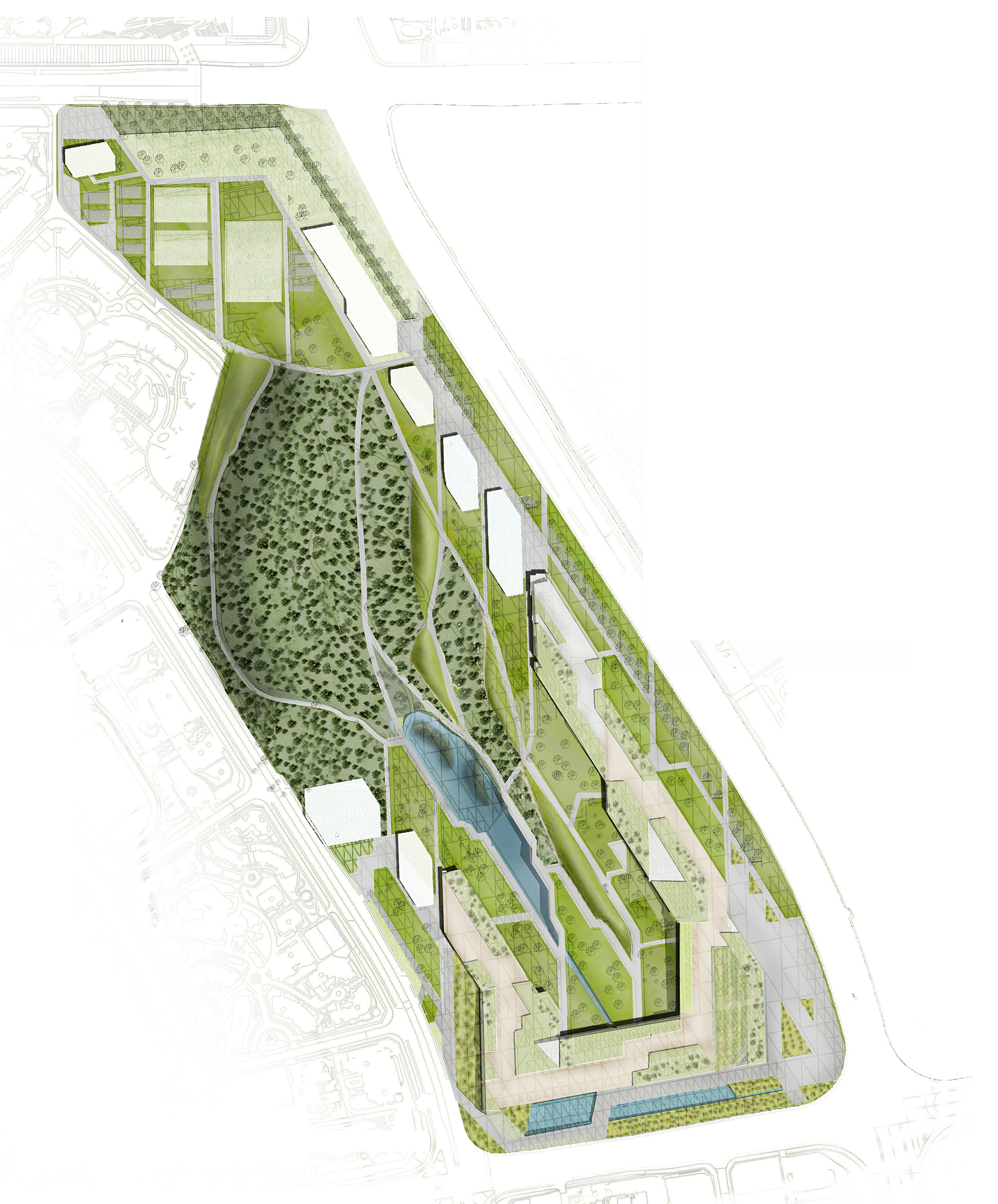
Xiangmi Park, Shenzhen, China
OCEAN CN & SED Landscape Architects team up for a Joint Venture for this International Competition to design and Urban Park in Shenzhen.
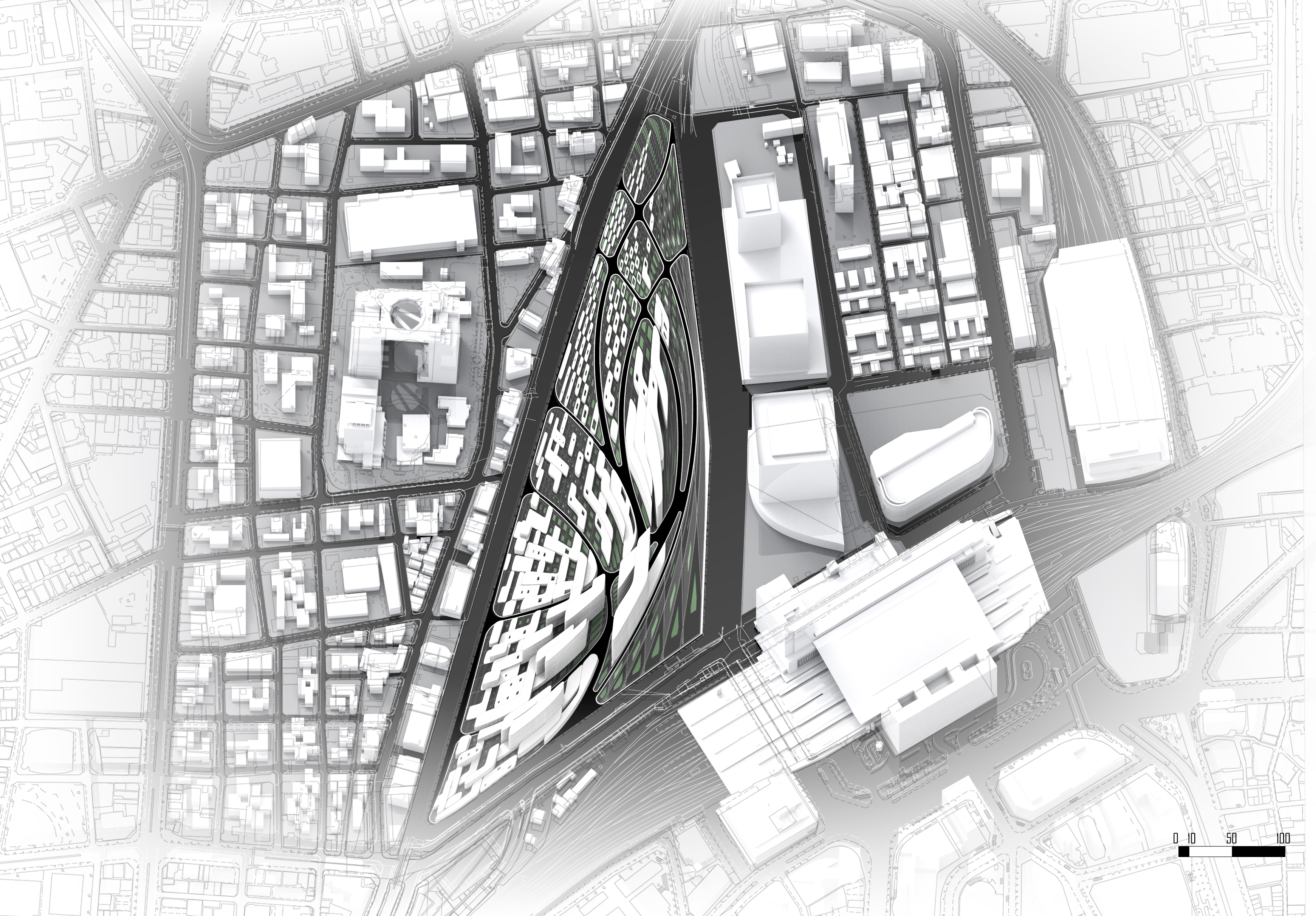
Umekita Second Development Area, Osaka Station
Commission: City of Osaka, Japan OCEAN CN: Tom Verebes, Mohamad Ghamloush, Nathan Melenbrink) Role: Tom Verebes (Creative Direction, Conceptual Design, Presentation Production Coordination) With Arup Transportation & Arup Structural Engineering, Hong Kong • International Invited Limited Design Competition: OCEAN CN Invited to first stage by Tadao Ando and Kengo Kuma • Organisers: Secretariat of the […]
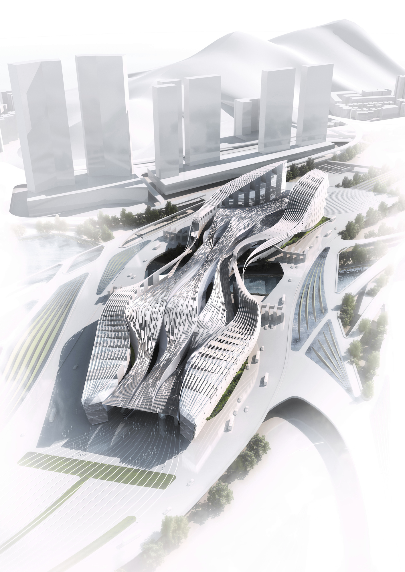
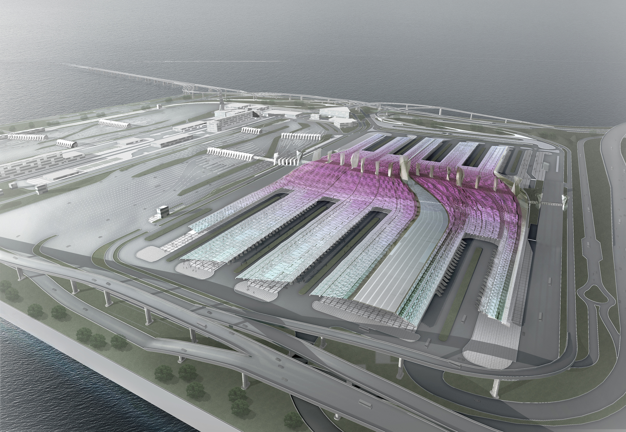
Liantang /Heung Yuen Wai Boundary Control Point Terminal Building
Proposing a new border crossing for Hong Kong and Shenzhen involves the parallel yet divergent ecological, planning and political histories, in which the Hong Kong side is characterized primarily with wild protected landscapes and topographies, while the Shenzhen side is overwhelmingly artificial and urban. This project confronts these dichotomous characteristics and aims to correlate the categories of the artificial and the natural, proposing one singular building across the border, in which the vast flows of people and vehicles are channeled. The spatial and temporal concepts driving this proposal are informed by the graphic qualities of traditional Chinese Calligraphy. Three devices are used to inscribe the connection between the Hong Kong side and the Shenzhen side: Firstly, the offices are raised above the Passenger Crossing to either side of the building in order to bring light into the deep space of the BCP building. Secondly, a series of evolving tectonic roof bands peel off from one another on the first floor, so that the enclosed ground floor establishes a direct connection to the sky. Lastly, the massing between the structural frames which articulate the offices is interspersed with landscape planting.

Yan Jiao Hua Run 4D City Masterplan
Yan Jiao Hua Run 4D City Masterplan, Hubei Province, China Commission: CR Corporation, China State Developers Joint Venture: dotA (Beijing) & OCEAN CN (Hong Kong) dotA: Gao Yan, Duo Ning, Chiang Qiang, Wang Xin, Crystal Yiu OCEAN CN: Tom Verebes, Nathan Melenbrink Role: Tom Verebes (Creative Direction, Production & Post-production Project Coordination) Publications: Verebes, T. […]
FUTUREPort
FUTUREPort Exhibition: Counterpart Cities: FUTUREPORT Hong Kong-Shenzhen Bi City Biennale 2011 Curator: Solomon, J., Tang, D. Venues/Dates: OCT Loft, Shenzhen (9 December, 2011 – 4 February, 2012) Central Market Oasis Gallery, Hong Kong, February-March 2012 Featuring: Featuring the FUTURE PORT Project, conduced as a research project within a research team at HKU (Verebes, T. Principal Investigator PI). […]
Hong Kong-Zhuhai-Macau Bridge – Hong Kong Boundary Crossing Facility
Our proposal for the Masterplan distributes a multiplicity of graphic spatial systems, derived from transformations of traditionnal Chinese patterns, forming arrays of surface bands, point clouds and spiraling fractal lines. The systems deploy soft landscaping, hard landscaping, pedestrian and service routes, and facilities across the site. Each spatial system is operated upon with forces simulating earthquake forces and effects on the ground. The result is a space, achieving an urban density to the park, with a coherent yet diverse spatial organization, and a central area which serves as a monument to the Earthquake, and also locating the Museum building. The ruins are encircled with a pedestrian route, enabling people to look at the ruins in a safe yet proximate vantage.

Parametric Pearl River Delta
Parametric Pearl River Delta Exhibition: Hong Kong-Shenzhen Bi-City Biennale 2009 Curators: Dr. Schuldenfrei, E., Yiu, M. Venue: West Kowloon Waterfront Promenade, Kowloon, Hong Kong SAR Dates: 3 December 2009 – 27 February, 2010 Featuring: OCEAN CN Design Project: “Parametric Pearl River Delta PPRD”, Commissioned Research Project, HK-SZ Biennale09, including UGC Funded Research (Seed Grant No. 200905159014) OCEAN.CN, in collaboration […]
Urban China Research
This research project was commissioned for the January 2009 issue of Urban China focuses on the unprecedented rate and extent of urbanization in China, addressing issues associated to the obsolescence of cities and buildings. Far from a celebration of impermance and ephemerality, we will deal with questions of environmental, economic, cultural and social endurance within the context of rapid urban transformation in China. This project investigates alternatives to the typologies of high rise towers, perimeter block mass, and suburban sprawl, as the default architectural and urban typologies deployed in China’s urban densification and expansion, and the dominant models of its urban growth.
Rabin Square
A modulated series of 18 looped object configurations are distributed along an open line, originating from the geographical point of assassination of Yitzak Rabin. The objects grow and change in incremental gradients as a serial event field, both within each object as well as across the range of 18 objects. A homogenous parallel field is interrupted by the 18 insertions, causing an iterative transitional field of 18 events. Each ‘position’ is an ‘event’. The objects increase in magnitude/size, each with a position of its centroid at a continuous and uniform oblique datum level that relates to the +/-3.50 level of the upper terrace. The modulation between each position and the preceding/subsequent position will cause a topographical flow of convex and concave podia, evolving from the surface of the square. A irrigation topography interacts and responds as a geometric iteration of the range of objects, acting as a mechanism of local re-orientation of pedestrian movement, between each object. The upper terrace of the Municipality Building [City Hall] is linked with the +/-0.00 level, reconfiguring the stairway with an integrated terracing topography. The scheme deploys a distribution of water pools, aquatic and desert planting, seating, information and material surfaces within the topographies of the directional field, as an open space for 300,000 people to gather.
Martin Luther King Memorial
In the Martin Luther King Memorial, laminated pre-stressed concrete slabs of 1m width organise the flow of people along scripted vectors. The small sectional increments allow for the surface discontinuities to act as pedestrian steps, as well as providing structural intersections which bind two sets of trajectories together. The elements can be manufactured as segmented slabs. The primary cultural question concerning this project is the extent to which a ‘memorial’ has the capacity to recapitulate the ongoing affects of the Civil Rights Movement’s struggle against apartheid. Can architecture install the spatial organisation of the collective movement of people along parallel trajectories, in rows of protesters marching side-by-side? To what extent does the spatial organisation of the 1960’s marches register in the way the individual [as part of a collective] moves in, through and on the memorial? George W. Bush was elected to serve as President in 2000, and the monument was never built.